


Severe weather is set to hit parts of the state on Monday including Mandurah.
A cold front is expected to pass over the South West on Monday morning producing thunderstorms and gusty showers.
LATEST BUREAU OF METEOROLOGY ALERT:
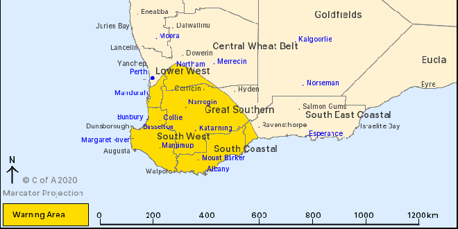
Get ready now for severe weather in parts of the South West, Goldfields-Midlands, Great Southern, Perth Metropolitan, Lower South West
If you live in South West, South Coastal, Great Southern and parts of Lower West and Central Wheat Belt districts you need to get ready now for the severe weather coming Monday morning and afternoon.
Locations which may be affected include Albany, Bunbury, Katanning, Mandurah, Manjimup, Margaret River, Mount Barker, Narrogin and Northam.
This weather is typical of a winter-time cold front, but is occurring unseasonably late in the year.
WHAT TO DO:
DFES has these tips to help you and your family get ready now:
- Store or weigh down loose objects around your home like outdoor furniture that could be picked up and thrown by strong winds, causing damage or injury
- Ensure your emergency kit is complete including a battery operated radio, torch, spare batteries and first aid kit
- Ensure pets and animals are in a safe area
- Move vehicles under cover
- Boat owners should securely moor their boats
- Campers should find safe shelter away from trees, powerlines, storm water drains and streams
- Unplug electrical appliances and avoid using landline telephone if there is lightning.
If you are away from home contact family or friends to prepare your property.
WEATHER DETAILS:
At 08/11/2020 16:32:00 the Bureau of Meteorology advised a cold front approaching from the southwest is likely to produce gusty showers and thunderstorms as it moves across southwestern WA during Monday morning and afternoon. Thunderstorms associated with the front may produce DAMAGING WINDS, averaging 60 to 70 kilometres per hour with peak gusts to around 90 kilometres per hour, which could cause DAMAGE TO HOMES AND PROPERTY. Thunderstorms are most likely to occur on the frontal boundary, which is expected to move across the South West Capes around sunrise, moving northward to reach Mandurah in the late morning and then extending eastwards across the Central Wheat Belt, Great Southern and South Coastal districts during the afternoon. Showers and thunderstorms associated with the front may also produce HEAVY RAINFALL southwest of a line from Bunbury to Windy Harbour which may lead to FLASH FLOODING during Monday morning. Gusty conditions will continue across southwestern WA in the wake of the front.
ROAD CLOSURES AND CONDITIONS:
Roads have not been closed.
Take extra care on the roads and do not drive into water of unknown depth and current.
Road information may also be available from Main Roads WA by calling 138 138 or visiting travelmap.mainroads.wa.gov.au or by contacting your Local Government Authority.
WHAT EMERGENCY SERVICES ARE DOING:
- DFES is monitoring the situation.
IF YOU NEED ASSISTANCE:
- If your home has been badly damaged by a storm, call the SES on 132 500
- In a life threatening situation call 000
After a storm SES volunteers make temporary repairs to homes that have been badly damaged, such as roofs that have been ripped off or large fallen trees on homes or cars. Please contact your insurance company to organise permanent repairs.
 Perth to Bunbury train service returns
 Missing woman found safe and well
 Community fed up with teenage hoons terrorising Halls Head oval
 Southern suburbs electrician claims $1.8 million Lotto win
 Works continue on Pinjarra's Munday Avenue extension
 Halls Head support worker charged with historic child sex offences
 Severe thunderstorm warning cancelled for Mandurah, Bunbury
 Fortnightly red bin collections to remain in the City of Rockingham after council rejects motion
 Rate rises on the way for Rockingham, Mandurah ratepayers