


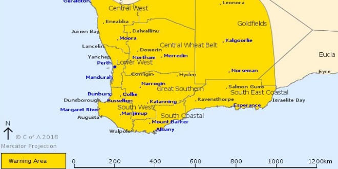
A severe weather warning remains in place with strong winds and a possible storm forecast for Mandurah.
The Bureau of Meteorology's severe weather warning for the lower west remains in place today.
More rain and wind gusts are predicted to sweep across Mandurah this morning, with this kind of weather forecast only seen about five times per year in Western Australia.
There's already been 6.6mm of rain recorded with wind gusts reaching 78km/h just after five o'clock this morning.
The bureau said a strengthening northerly flow ahead of a strong cold front will cause damaging winds and abnormally high tides ahead of a strong cold front that will move through during Tuesday.
The front is expected near the southwest Capes about 8am Tuesday morning and lie near Perth to Albany at around midday.
Wind gusts are expected to reach 100km/h with the threat of damage to homes and property lingering for coastal areas including the Peel region.
Winds will ease over western coastal parts during Tuesday afternoon.
The heaviest rainfall is expected on the coast between Jurien Bay and Walpole.
The Department of Fire and Emergency Services is advising people to find shelter away from trees and power lines if outside today.
People inside should stay away from windows, unplug electrical appliances and tie down loose outdoor items.
Mainroads is also reminding motorists to use caution on the roads.
 Men charged after traffic stop in West Pinjarra leads to 80kg drug seizure
 Green waste fees waived for Mandurah residents after weekend storms
 Concerns for missing Rockingham boy
 'Prognosis terrifying' for young boy struck by car in Cooloongup
 K9 Rescue's long-term resident in desperate search for loving home
 West Coast Radio announcer Darragh O’Dea takes out Best Local Show at Australian Audio Awards
 Lucky escape for two people after boat smashes into Mandurah Estuary Bridge
 Secret Harbour Golf Links to host WA's most prestigious golf tournament
 Upgrades begin on Kwinana Loop Trail