


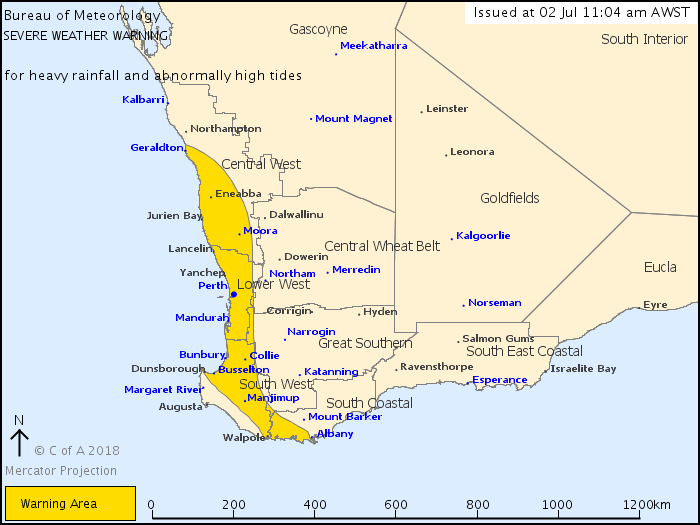
There is a Severe Weather Warning for heavy rainfall and abnormally high tides for people in Lower West, South West and parts of Central West and South Coastal districts.
Heavy rain and high tides possible over southwest WA during Monday as a rain band and cold front move through. The threat of damaging winds has eased for Monday.
Weather Situation:
A rain band and cold front are currently moving through southwest WA. The system is bringing heavy rainfall and abnormally high tides. Conditions will ease over southern parts during Monday afternoon and early evening and northern parts overnight Monday.
HEAVY RAINFALL that may lead to FLASH FLOODING is currenly occuring southwest of a line from Mandurah to Albany. HEAVY RAINFALL will then extend as far north as the Perth area around midday Monday, and through the remainder of the warning area by 5pm Monday. Rain should start to ease over southern parts of the warning area Monday afternoon and early evening and over northern parts overnight Monday.
Tides between Shark Bay and Cape Leeuwin are likely to rise above the normal high tide mark with very rough seas and potential flooding of low-lying coastal areas around the time of high tide until Monday afternoon, particularly within Geographe Bay.
This is typical weather for this time of the year but heavy rain may cause damage to propety and make road conditions hazardous.
The threat of damaging winds over the South West has eased, however winds are expected to increase again southwest of a line from Bunbury to Albany from early Tuesday morning.
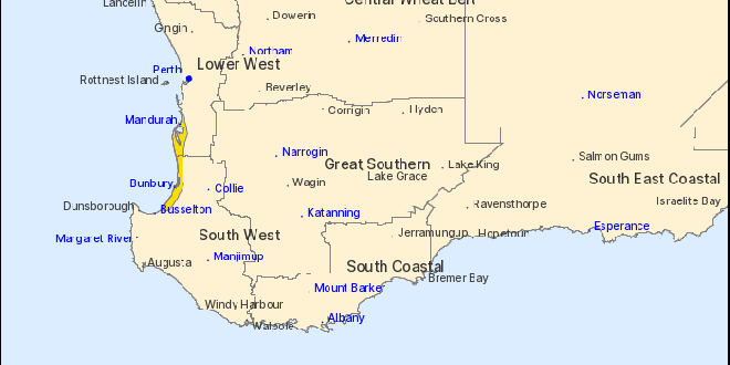
Areas southwest of a line from Cape Naturaliste to Walpole are no longer experiencing severe weather for the remainder of Monday and the warning for this area is CANCELLED.
Locations which may be affected include Bunbury, Busselton, Geraldton, Mandurah, Manjimup, Moora, Perth, Lancelin, Walpole and Yanchep.
A wind gust to 130 kilometres per hour was recorded at Cape Leeuwin at 5.03am Monday morning.
Heavy rainfall has been observed at Willmots Farm with 54.8mm recorded between 5:00am and 8:00am. Other rainfall totals recorded in the 12 hours between 11:00pm and 11:00am:
Margaret River 70mm
Beedelup 63mm
Bunbury 48mm
A second cold front and associated low are expected to affect southern and southwest parts of WA over the coming days with the potential for further severe weather on Tuesday morning and during Wednesday.
The Department of Fire and Emergency Services advises that people should:
* If outside find safe shelter away from trees, power lines, storm water drains and streams.
* Close your curtains and blinds, and stay inside away from windows.
* Unplug electrical appliances and do not use land line telephones if there is lightning.
* If boating, swimming or surfing leave the water.
* Be alert and watch for hazards on the road such as fallen power lines and loose debris.
* Keep away from flooded drains, rivers, streams and waterways.
* Be careful of fallen trees, damaged buildings and debris.
* Be careful of fallen power lines. They are dangerous and should always be treated as live.
* Assess your home, car and property for damage.
* If damage has occurred take photos and contact your insurance company to organise permanent repairs.
* If your home or property has significant damage, like a badly damaged roof or flooding, call the SES on 132 500.
 Perth to Bunbury train service returns
 Missing woman found safe and well
 Community fed up with teenage hoons terrorising Halls Head oval
 Southern suburbs electrician claims $1.8 million Lotto win
 Works continue on Pinjarra's Munday Avenue extension
 Halls Head support worker charged with historic child sex offences
 Severe thunderstorm warning cancelled for Mandurah, Bunbury
 Fortnightly red bin collections to remain in the City of Rockingham after council rejects motion
 Rate rises on the way for Rockingham, Mandurah ratepayers